The United States of Baseball
The New York Times Upshot did a great interactive on the various fan allegiances of baseball fans by zipcode. The results weren’t surprising: the Yankees are the default where there’s no teams, the Mets and A’s don’t have a plurality, and the Braves and Cubs expand well beyond their geographies – mostly because of their long standing Regional Sports Network broadcast reach. The granularity of the detail produced, however, led to some great specifics – there’s the disputed New England border that runs through Connecticut, the Northern California/Southern California dividing line pinpointed at Tulare, CA, and many other fun tidbits.
Nate Silver of Five Thirty Eight tweeted about how his office was using the map to define geographic boundaries, which I thought was enlightening.
The @FiveThirtyEight office consensus is that the Midwest begins at the Phillies-Pirates dividing line. http://t.co/WNteznrRoY
— Nate Silver (@NateSilver538) April 29, 2014
Pennsylvania can’t be the Midwest, but Pittsburgh can’t be the Northeast. Drawing region boundaries through states just makes sense. Using the NYTimes Baseball Map just made sense. Using that methodology, I decided to take the example to the logical conclusion: redefine the US by baseball allegiance.
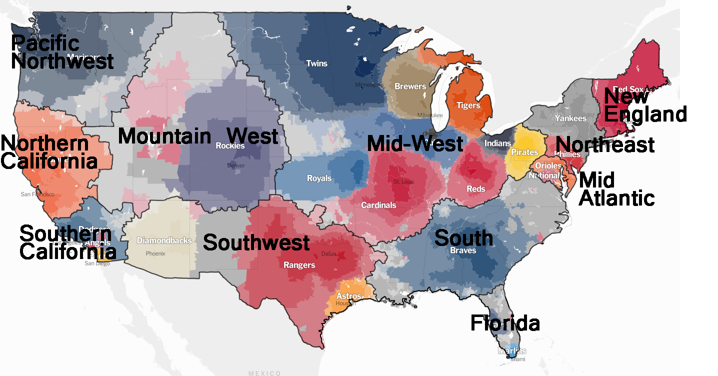
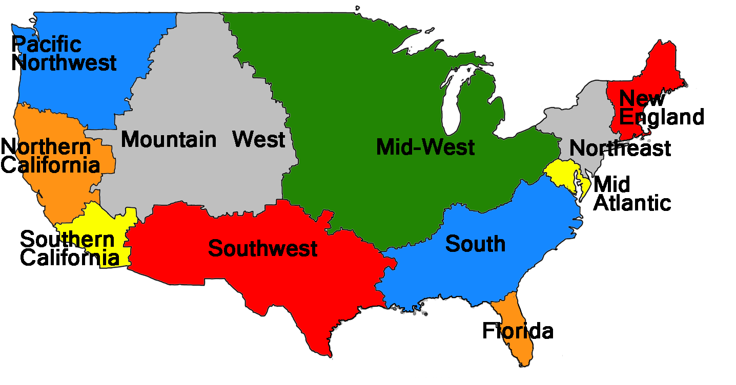
There were three difficult areas on the map.
- What to do about the Mid-Atlantic? I’ve always thought of Philadelphia as firmly Northeast, and Virginia as the South, but clearly wedged in between the two is the Mid-Atlantic. I don’t think anyone would dispute this region’s existence. However, it’s very small, especially by geographical area. I wanted to make the Mid-Atlantic bigger, but how? It made more sense to expand it south than north. Very few people from Philadelphia would call their home “Mid-Atlantic” and I would guess that almost all would call it “the Northeast.” Expanding south meant shrinking the region known as the South, and doing so along the baseball borders means that all that unincorporated land currently known as southern Virginia, North Carolina, and northern South Carolina would be part of Mid Atlantic. This wasn’t too bad, for instance, Raleigh and Richmond can definitely qualify as Mid-Atlantic. In fact, Five Thirty Eight also did a study on what the local population considers themselves, and only about 50% of North Carolinans consider themselves part of the South. However, redrawing the Mid-Atlantic in this way would mean expanding west into the unincorporated land of West Virginia. This just feels wrong. How can a state be Mid-Atlantic if it doesn’t have a coast line? As a result, I held the (very small) Mid-Atlantic region where it was.
- How far does the Mid-West go? Pretty far, it turns out. I didn’t want to subdivide the Mid-West into things like North Central, Plains, High Plains because, while geographically impressive, there’s simply not a lot of people there. It’s not that they don’t have their own identity, as much as there’s not enough critical mass to make it an important enough region, on par with the Mid-West for instance.
- Is Texas a Thing? Yeah, Texas is a thing, but I put them in the Southwest. People from Arizona or New Mexico might not like this, but I grouped these together. It was a little difficult to figure out where to stop the Southwest, but at some point, you hit the Rocky Mountains, and a very different fan base in Colorado. I decided to put the unincorporated land of Nevada in the Mountain West.
It’s possible that New England isn’t its own region, just like the Mid-Atlantic, but it’s tough to put Baltimore, Washington, and Northern Virginia in the same region as Boston. I took a look at the population numbers for the 60 largest Metropolitan Statistical Areas based on 2013 estimates and divided them up by my new region assignment. The 60 largest MSAs get you about 183M people, of 313M in the US. New England does seem to hold its own, as it’s slightly larger than the Pacific Northwest, and much bigger than the Mountain West. The problem with regions like New England, Pacific Northwest, and Mountain West is that they are really based only on one city. The Northeast is mostly based on one city, but it also has Philadelphia to increase its numbers.
| Region | Population | Percentage |
| Mid-West | 38,603,614 | 21% |
| Northeast | 31,234,633 | 17% |
| Southwest | 27,126,274 | 15% |
| Southern California | 19,325,823 | 11% |
| South | 16,165,138 | 9% |
| Northern California | 13,032,565 | 7% |
| Florida | 12,361,230 | 7% |
| Mid-Atlantic | 8,720,597 | 5% |
| New England | 7,215,300 | 4% |
| Pacific Northwest | 5,924,659 | 3% |
| Mountain West | 2,697,476 | 1% |
Other fun stuff: Southern California includes Las Vegas, so maybe it needs another name. The Pacific Northwest contains Idaho, which has no coast. The Southwest includes a little bit of Louisiana. A tiny bit of Georgia sneaked into Florida, which was surprising, as I thought it would go the other way. If southern Virginia, North Carolina, and northern South Carolina were part of the Mid Atlantic, it would only have increased to about 10M in population based on the above chart, so while it would look more geographically impressive, it would still be a fairly small region.